Ağrı Province
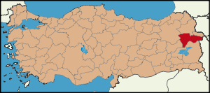
| Location of Ağrı Province in Turkey | |
|---|---|
 |
|
| Overview | |
| Region: | Eastern Anatolia Region, Turkey |
| Area: | 11,376 km2 (4,392 sq mi) |
| Total Population | 571.243 TurkStat 2007 (est) |
| Licence plate code: | 04 |
| Area code: | 0472 |
| Governor Website | http://www.agri.gov.tr |
Ağrı is a province on the eastern borders of Turkey, bordering Iran to the east, Kars to the North, Erzurum to the Northwest, Muş and Bitlis to the Southwest, Van to the south, and Iğdır to the northeast. Area 11,376 km². Population 571,243 (2006 est).
The provincial capital is Ağrı, situated on a 1,650 m. high plateau.
Contents |
Etymology
In the Ottoman Empire era the area was called Şorbulak, and Karakilise (black church) which was then mutated to Karaköse (the black man with no moustache) towards the end of the Ottoman period.
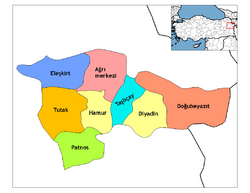
Districts
Ağrı province is divided into 8 districts (capital district in bold):
- Ağrı
- Diyadin
- Doğubeyazıt
- Eleşkirt
- Hamur
- Patnos
- Taşlıçay
- Tutak
Geography
Ağrı is named after the nearby majestic Mount Ararat, a 5,165 m (16,945 feet) high stratovolcano, the highest mountain in Turkey. It can be climbed from here and can be seen from parts of Armenia, Iran, Georgia, and Azerbaijan. The nearest town to the mountain is Doğubeyazıt.
46% of the province is mountainous, 29% is plain, 18% is plateau, and 7% high meadow. As well as Ararat there are many other peaks over 3,000m, including Aladağlar and Tendürek. The plains are fertile, being covered in volcanic deposits, and are used for growing grains and grazing. Various tributaries of the Murat River (which later feeds the Euphrates) flow through the area and water these plains. The high meadows are used for grazing.
The weather here is very cold (temperatures as low as -52°C (-56°F) in winter) and the mountainsides are mainly bare. There are a number of important passes and routes through the mountains.
History
The plateau of Ağrı was historically controlled by the Kingdom of Urartu until its transition to the Orontid Dynasty of the Kingdom of Armenia. The area was coveted by many foreign invaders as a gateway between east and west. It was conquered numerous times by Assyrians, Greeks, Romans, Byzantines, Arabs, Mongols, Persians, and finally by the Seljuq and Ottoman Turks.
The first Turkish presence in the region was the brief occupation of the Doğubeyazıt area by the Saka in 680. The first Muslims in the area were the Abbasids in 872. The Turkish hordes began to pass through in huge numbers following the defeat of the Byzantine armies at Malazgirt in 1071, sometimes pursued by Mongols. The land was brought into the Ottoman Empire by Sultan Selim I following the Battle of Chaldiran.
Under Ottoman rule, the area that is now the Ağrı Province mostly consisted of Kurds. The former lived fairly well until the Hamidian massacres and the Armenian Genocide. Those Armenians who managed to escape liquidation fled north to Russian Armenia.
Recent events
On August 19, 2006, a Turkish-Iranian natural gas pipeline exploded in the province. Turkish authorities suspect separatist PKK was behind the incident.[1]
Ağrı today
People live by grazing animals and Ağrı also attracts tourists to the mountain, for climbing and trekking in summers, and skiing in winters; and also some are keen to see places of interest such as:
- Ishak Pasha Palace and what some claim to be the second-largest meteor crater in the world which in fact is the crater of Mount Tendürek in Doğubeyazıt
- Aznavur Tepe in Patnos
- The tomb of Ahmedi Hani in Diyadin.
See also
- 2007 Ağrı earthquake
External links
References
- ↑ "Gas pipeline explodes in Turkish rebel region". CNN. 2006-08-19. http://web.archive.org/web/20060824161603/http://edition.cnn.com/2006/WORLD/asiapcf/08/19/turkey.pipeline.ap/. Retrieved 2008-04-04.
|
||||||||||||||||||||||||||||||||||
|
|||||||